Petroleum Geoscience Module G11PG
{`Course Code: G137/G13W/X
INSTITUTE OF PETROLEUM ENGINEERING
HERIOT-WATT UNIVERSITY
DEGREE OF MSc / DIPLOMA IN PETROLEUM ENGINEERING
PETROLEUM GEOSCIENCE – Module G11PG
`}
Section A
Explain what you understand about the following terms or topics that relate to petroleum geoscience. Use a sketch or example as appropriate. Write your answers in the gold book provided. Do not bother to write the question numbers on the front of the exam book (we will assume all are answered).
[Answer ALL 25 Questions, 2 marks each]
A1
Normal and reverse faults
(2 marks)
A2
Difference between heterogeneity and anisotropy
(2 marks)
A3
Unconformity
(2 marks)
A4
Transgression and regression
(2 marks)
A5
Wavelength and frequency of acoustic waves
(2 marks)
A6
Trough cross-bedding
(2 marks)
A7
Grain size and sorting
(2 marks)
A8
Plunging anticline
(2 marks)
A9
Paleozoic, Triassic and Oligocene (exact numerical ages are not important)
(2 marks)
A10
Secondary porosity
(2 marks)
A11
Crust and lithosphere
(2 marks)
A12
Secondary migration
(2 marks)
A13
Plate boundary
(2 marks)
A14
Clastic sedimentary rocks
(2 marks)
A15
Walther’s Law
(2 marks)
A16
Stratigraphic traps
(2 marks)
A17
Timing (in a petroleum play)
(2 marks)
A18
Hanging wall and footwall
(2 marks)
A19
The abbreviations STOIP, GIIP, TD and TVDSS
(2 marks)
A20
Two-way-time
(2 marks)
A21
The difference between proven and probable reserves, as defined by the SPE
(2 marks)
A22
Deltaic deposits
(2 marks)
A23
Bioturbation
(2 marks)
A24
Lithostratigraphy
(2 marks)
A25
Source rock
(2 marks)
Section B
Answer TWO questions from Section B. Each question is worth 25 marks. Write your answers in the green book provided. Be sure that any loose pages showing your work are attached. Do not answer more than two questions from this section. Put the question numbers on the front of the answer book.
B26
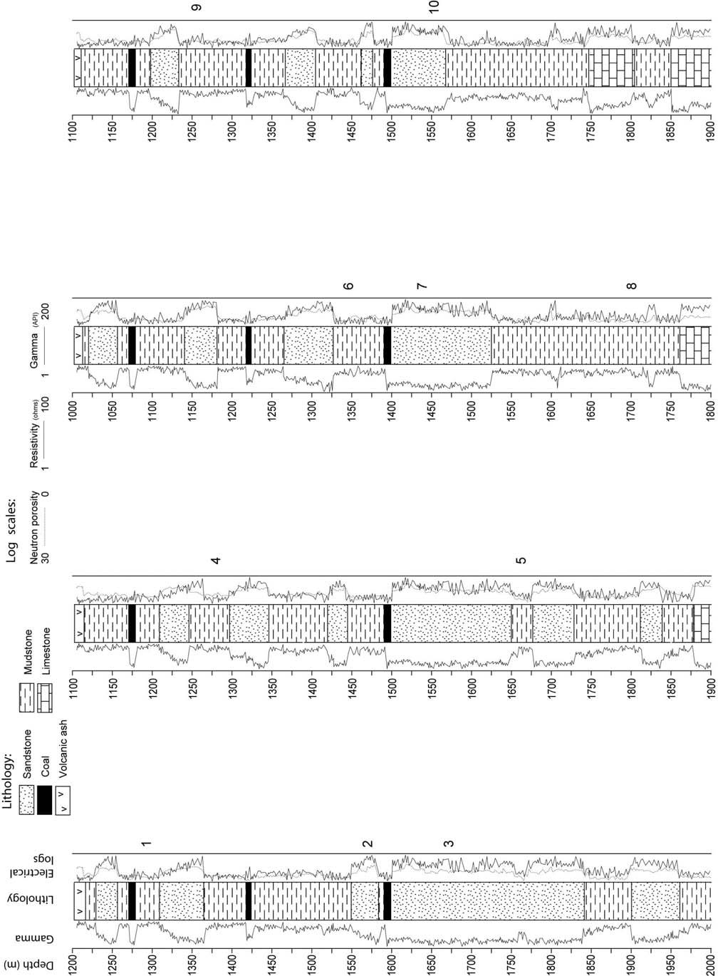
Attachment B26 shows interpreted lithology and wireline logs for four wells (note depth scales and lithology key). The logs have been ‘hung’ off a regionally deposited ash horizon recognized in each well. Samples taken from each well (numbered 1-10 on the logs) were analyzed and the microfossils found indicated marine environments for samples 3, 5, 7, 8
and 10, and non-marine environments for samples 1, 2, 4, 6, and 9.
- On the attachment, use the lithology shown and the shape of the wireline logs to construct a correlation panel for the four wells. Keep in mind that the idea is to show the lateral continuity (or lack of continuity) of the potential reservoir and seal rocks, and other lithologies.
(8 marks)
- Give reasons why you correlated the lithological units as you did, specifically mentioning the different depositional
(6 marks)
- Sketch (draw) in your answer book what you think a structural cross-section through the wells would look like. What further information would you need in order to draw an accurate cross- section?
(6 marks)
- Indicate on your sketch the location of possible structural and stratigraphic
(5 marks)
B27
The following data are available for a short interval in a well
|
Permeability | |
|
Depth (m) |
(mD) |
|
1440.0 |
180.00 |
|
1440.3 |
18.00 |
|
1440.6 |
15.00 |
|
1440.9 |
19.00 |
|
1441.2 |
70.00 |
|
1441.5 |
132.00 |
|
1441.8 |
98.00 |
|
1442.1 |
112.00 |
|
1442.4 |
42.00 |
|
1442.7 |
24.00 |
|
1443.0 |
15.00 |
|
1443.3 |
16.00 |
|
1443.6 |
17.00 |
|
1443.9 |
1.00 |
|
1444.2 |
1.00 |
- Calculate arithmetic, harmonic, and geometric averages, and the median and mode for permeability. What might be the reason for the differences between averages?
(10 marks)
- Determine the tolerance level of the data and hence the range of the arithmetic average. What sample spacing should be used to measure the arithmetic average within 20%?
(10 marks)
- Describe the stratigraphic conditions whereby the arithmetic, harmonic and geometric average might be used to calculate the effective permeability of this
(5 marks)
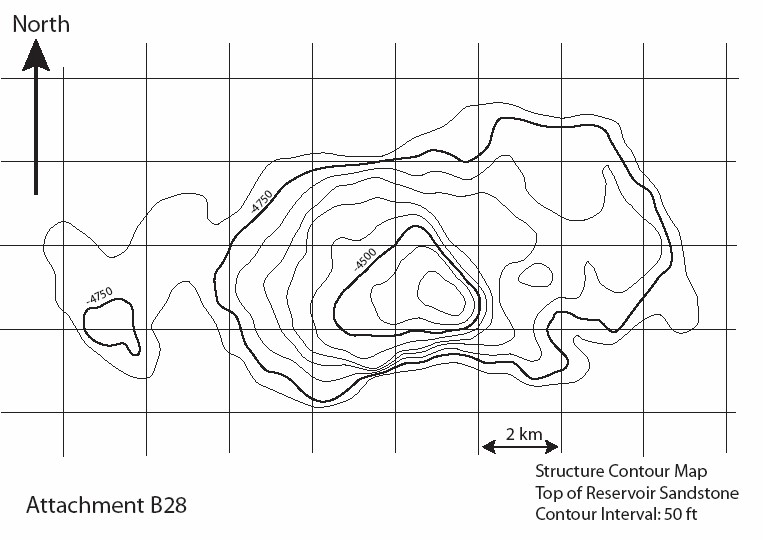
B28
A structure map is given for the Nubian Sandstone Pyramid Field in the Egyptian Western Desert (Attachment B28)
The x and y coordinate system of the map is indicated in metres. Use this scale to estimate the area and hence gross-rock volume for the field.
Depth contours are given in feet below sea level at every 50 foot interval. The crest of the structure is at 4380 feet below sea level. The pay sands are more than 400 feet thick.
- Calculate the oil-in-place, given the following information:
There is no free gas in the structure
|
Oil water contact |
4750 feet below sea level | |
|
Porosity |
0.18 | |
|
Water Saturation |
0.15 | |
|
Oil Shrinkage factor |
1.05 | |
|
Net:gross |
0.8 | |
|
(10 marks) |
- Explain the procedures you would use to produce a probabilistic estimate for the oil-in-place in this
(10 marks)
- What drive mechanism might you expect in this field and what recovery factor would you expect?
(5 marks)
B29
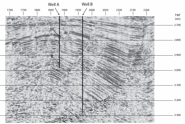
Attachment B29 shows a portion of a seismic reflection survey from an offshore location in southeast Asia. The shotpoint spacing is 25 metres. The data shown range from about 2.6 sec TWT to about 3.4 sec TWT. Well A was drilled a few years ago at the location indicated on the attachment. In Well A, hydrocarbon shows were noted over an interval (indicated as “M”) from -2361 m TVDSS. Shows and log-calculated pay were again noted from -2549 m TVDSS (indicated as “R”). When the operator attempted to conduct a test of this lower interval, mechanical problems caused the tool to become stuck, and no test was conducted.
The hole was plugged and abandoned. Subsequently, another seismic survey was conducted, resulting in the image presented here. Based on this later survey and the information from Well A, a new drilling location (marked as Well B) has been proposed. This question is concerned with making predictions about what will be encountered in Well B.
- On Attachment B29, draw an interpretation that highlights the major features. In the exam book, write a short summary of the geological history as indicated by the seismic
(5 marks)
- At the location of Well B, the water bottom appears at a TWT of
1.199 sec (not shown on Attachment B29). Calculate the water depth. Assume that the velocity of seawater is 1496 m/sec.
(4 marks)
- In Well A, the water bottom is 7 metres shallower than at the location of Well B. Estimate the drilling depth of interval “M” in Well B. What assumption(s) do you need to make to perform this calculation?
(6 marks)
- Estimate the drilling depth of interval “R” in Well B. What additional assumption(s) do you need to make?
(6 marks)
- If the interval velocity below “R” is 2300 m/sec, what is the projected TD of Well B? Comment on the possible drilling risks at the indicated TD of Well
(4 marks)