Drilling Engineering Answers to Short Questions
Instructions:
- Explain what you understand about the following terms or topics that relate to petroleum geoscience. Use a sketch or example as
- Paleozoic, Devonian, Pliocene (exact numerical ages are not important)
- Basin
- Transgression and regression
- Fractures
- Plunging anticline
- Trough cross-bedding
- Deltaic deposits
- Turbidites
- Secondary sedimentary structures
- Crust and lithosphere
- Plate margin
- Lowest known oil (LKO)
- Reasonable range of oil and gas recovery factors for fields: a) under gas depletion, and b) under waterflood
- The abbreviations STOIP, GIIP, TD and
- Strike and Dip
- Gross rock volume
- Isopach
- Source rock
- Primary migration
- Metamorphic rocks
- Biostratigraphy
- Walther’s Law
- Triangulation
- True vertical thickness
- Seismic resolution
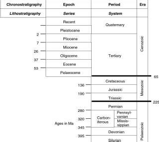
1. Paleozoic, Devonian, Pliocene (exact numerical ages are not important)
Paleozoic is an era – the oldest of the three (approx 540 to 250 Ma).
Devonian is a period within the Paleozoic era (~395 to 345)
Pliocene is a epoch within the Tertiary period of the Cenozoic era (the youngest era).
2. Basin
A basin is a large-scale (regional) depression where sedimentation is occurring and subsidence is continually creating accommodation space for more sediments to accumulate.
Basins form in many different plate tectonic settings, with subsidence caused by thinning of the crust (extension) or by loading (during compression).
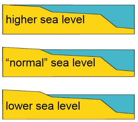
3. Transgression and regression
Transgression and regression refer to rise and fall of relative sea-level. Transgression occurs when relative sea-level rises and the shoreline moves landwards, regression occurs when relative sea- level falls and the shoreline moves sea-wards.
4. Fractures
A fracture is a break in the rock mass across which no relative movement has occurred. Fractures can be closed (by finer ground material or by crystalline fill creating ‘veins’) or open (creating secondary porosity and permeability). Fractures occur related to faults, folds and other structural deformation.
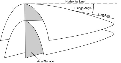
5. Plunging anticline
6. Trough cross-bedding
Trough cross-bedding is a sedimentary structure, created by the migration of megaripples or dunes with curved crests. The sets of cross-beds have curved erosional boundaries (set boundaries), and are greater than 5 cm thick (thickness is controlled by the height of the original beform, which is controlled by the flow). Curved crested megaripples represent a higher energy flow than straight crested megaripples.
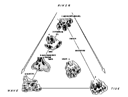
7. Deltaic deposits
Deltaic deposits are wedge-shaped volumes of sediment, deposited at the mouth of rivers where they meet a standing body of water (lake or sea). They are subdivided based on the dominant process – river, wave or tide. Reservoir facies in deltas include mouth-bars in fluvial dominated deltas, and shoreline facies in wave dominated deltas.
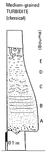
8. Turbidites
Turbidites are the deposits of turbidity currents, and are found in submarine fans (channelised and sheet turbidites) and on the basin floor (sheet turbidites). A turbidite is sharp-based (erosive, high energy flow), has a distinctive fining- upwards trend (because of the waning flow), a succession of sedimentary structures (massive, laminated, cross-bedded or convoluted, muddy) and may have internal grain alignment.
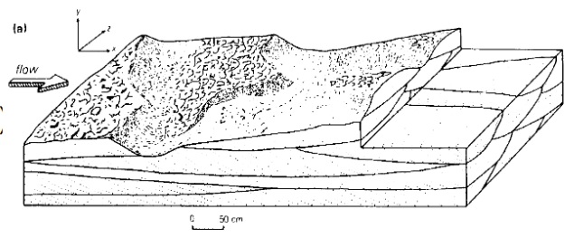
9. Secondary sedimentary structures
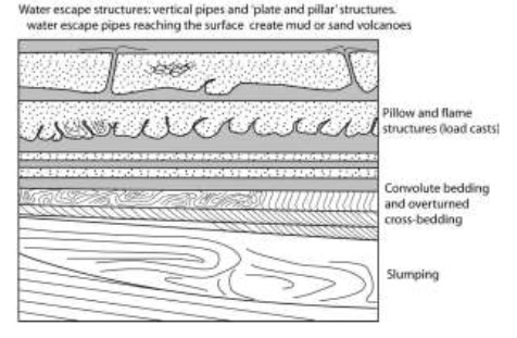
Secondary sedimentary structures are formed after the deposition of the sediment. They include bioturbation (the moving of the sediment by the action of animals), dessication cracks, raindrop imprints, and various soft-sediment deformation structures, including pillow structures, convolute lamination and water escape structures.
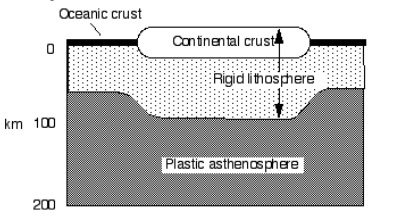
10. Crust and lithosphere
Crust and lithosphere are the outermost solid layers of the earth. Crust is the outer layer and is subdivided into two different types – oceanic and continental crust. Oceanic crust in thinner and composed of silica poor igneous rocks, continental crust is thicker and more silica rich, and contains sedimentary metamorphic and igneous rocks. The crust in combination with the outermost, solid, combination with the outermost, solid, layer of the mantle comprise the lithosphere, which is divided into plates that move around above a plastic, slowly convecting mantle layer – the asthenosphere.
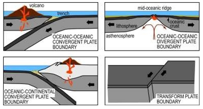
11. Plate margin
Plate margins or plate boundaries are the zones where two lithospheric plates meet. The relative movement of the plates means that they will either be separating (a divergent plate boundary), moving towards each other (a convergent plate boundary) or sliding past each other (a transform plate boundary).
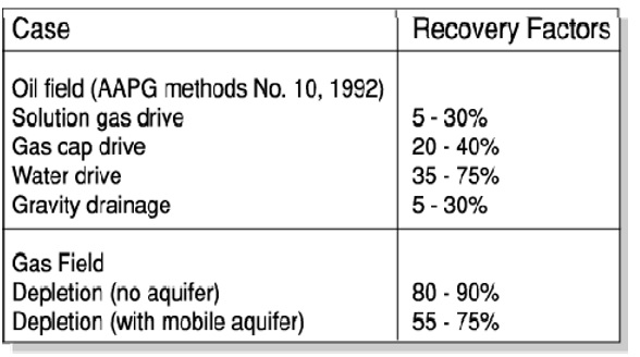
13. Reasonable range of oil and gas recovery factors for fields: a) under gas depletion, and b) under waterflood
Reasonable recoveries for oil and gas under different recovery mechanisms:
14. The abbreviations STOIP, GIIP, TD and TVDSS.
STOIP: Stock Tank Oil Originally/Initially In Place
GIIP: Gas Initially In Place TD: Total Depth
TVDSS: True Vertical Depth Sub-Sea
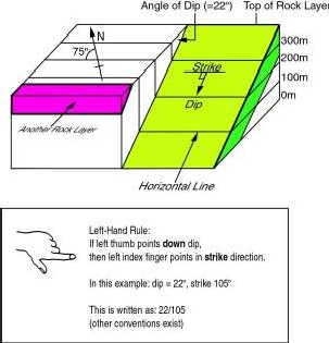
15. Strike and Dip
A way of defining the orientation of a planar surface: Strike is the orientation of a horizontal line on the surface, and dip is the angle between the surface and a horizontal plane.
16. Gross rock volume
The volume of rock in the structure that is filled with hydrocarbons – so between the top of the structure and the OWC. This can be the volume of reservoir rock (with the non-reservoir removed) if the reservoir is complex or in segments, or it could be the volume of rock including a certain proportion of non-reservoir material, which is then removed by applying a net- to-gross multiplier.
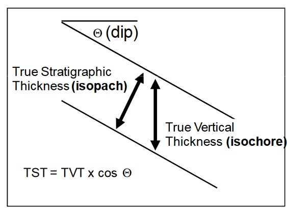
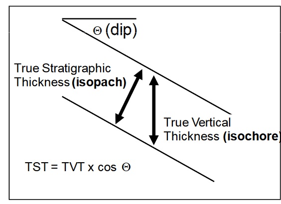
17. Isopach
A contour (line joining points of equal height) of true stratigraphic thickness values.
18. Source rock
The organic rich (5-20%) sedimentary rock that under the right temperature and pressure conditions generated hydrocarbons, which migrate upwards into reservoirs and traps.
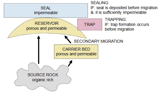
19. Primary migration
Primary migration is the initial migration out of the source rock (probably by means of hydraulic fracturing within the low permeability source due to overpressuring from volume expansion as hydrocarbons are created), into the surrounding rocks. Further migration of the hydrocarbons away, along carrier beds and into reservoir rocks is called secondary migration.
20. Metamorphic rocks
Metamorphic rocks are created when heat or heat and pressure on original sedimentary or igneous rocks causes changing of the mineral structures (recrystallization) without melting of the rock. Heating rocks (adjacent to igneous intrusions) create spotted rocks or hornfels, rocks under heat and pressure (burial) turn into schists and gneiss. The final rock type is dependent on the original rock composition – for example muddy sediments turn to schists, limestones to marble and quartz sandstones to quartzite.
21. Biostratigraphy
Biostratigraphy is the subdivision of the stratigraphic record (rocks) into units based on the presence, absence or grouping of fossils. Biostratigraphic units can be defined based on appearance and dissappearance of organisms, or by abundance of particular species.
Appearance and disappearance are linked to evolution and extinction of species, so that fossil species that are useful for biostratigraphy need to be types that occur in many different environments (are wide ranging) o that evolutionary changes affect the whole population, worldwide simultaneously.
22. Walther’s Law
Walther’s Law states that facies which appear in a vertical conformable succession, must have been deposited in adjacent depositional environments.
The movement of these environments through time, for example due to transgression and regression, causes deposition of the different facies above previously deposited facies from a different (but adjacent) depositional environment.
If facies which cannot be deposited in adjacent depositional environments appear in vertical succession, then the presence of an unconformity can be inferred.
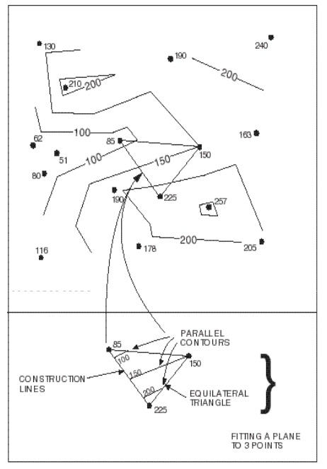
23. Triangulation
Triangulation is a techniques used for creation of contour maps, which is based on subdividing the area of the map into triangles with a data point at each corner, assuming each triangle represents a plane with a single gradient, and then contouring in straight lines across the assumed plane. This results in an unrealistic map, because of the angles of intersection of the final contour lines. It is therefore rarely used, but can be used in situations where different geologists have different interpretations of the available data. A map constructed by triangulation should be the same not matter who constructs it.
24. True vertical thickness
Thickness of a rock unit measured vertically – this is always greater than true stratigraphic thickness, depending on the dip. A contour of true vertical thickness is called an isochore.
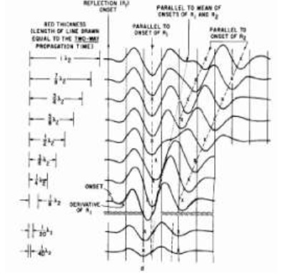
25. Seismic resolution
Seismic resolution is the minimum thickness that a rock layer must be in order that the top and bottom surfaces will be imaged by the seismic reflection survey (the unit will be ‘seen’ on the seismic line). It is generally assumed to be approximately ¼ of the wavelength of the seismic pulse.